
| Home
|
Maps and Views (23) Categories:
See Also:
Sites:
 » 1895 Map of Alaska
Oversized (2425 x 1700 pixels), detailed, colorful map of the entire state, by Rand McNally. http://fermi.jhuapl.edu/states/1895/ak_1895.jpg » AGDC Datasets
Elevation models, maps, and ftp geographic information sites for State of Alaska, Department of Natural Resources, U.S. Geological Survey, U.S. Department of the Interior, Bureau of Land Management, National Park Service, U.S. Fish and Wildlife Service, F http://agdc.usgs.gov/data/ » Alaska Climate Research Center
Maps showing both current and forecast Alaskan weather. http://climate.gi.alaska.edu/ » Alaska County Select
Map showing boroughs and census areas with links to statistics for the selected area provided by the U.S. Census Bureau. http://quickfacts.census.gov/qfd/maps/alaska_map.html » Alaska Geospatial Data Clearinghouse
Large collection of maps and data sets, including digital elevation, special-interest maps of environmental resources, maps of Arctic National Wildlife Refuge and other federal lands, and links to other state geographic data websites. http://agdc.usgs.gov/ » Alaska Map: Lonely Planet
A compact map showing locations of major cities and national parks. http://www.lonelyplanet.com/mapshells/north_america/alaska/alaska.htm » Alaska Map: National Geographic Society
A basic map designed to be easily duplicated for classroom use. Available in two versions, one with city names and one without. http://www.nationalgeographic.com/xpeditions/atlas/index.html?Parent=usofam&Rootmap=usak&Mode=d » Alaska Marine Highway System
Route maps and running times. http://www.dot.state.ak.us/amhs/TravelOptions/Routes/  » Alaska Volcanoes and Volcanics
Maps and graphics from the United States Geological Survey cover various areas of volcanic activity. http://vulcan.wr.usgs.gov/Volcanoes/Alaska/Graphics/framework.html » Aurora's Northern Nights
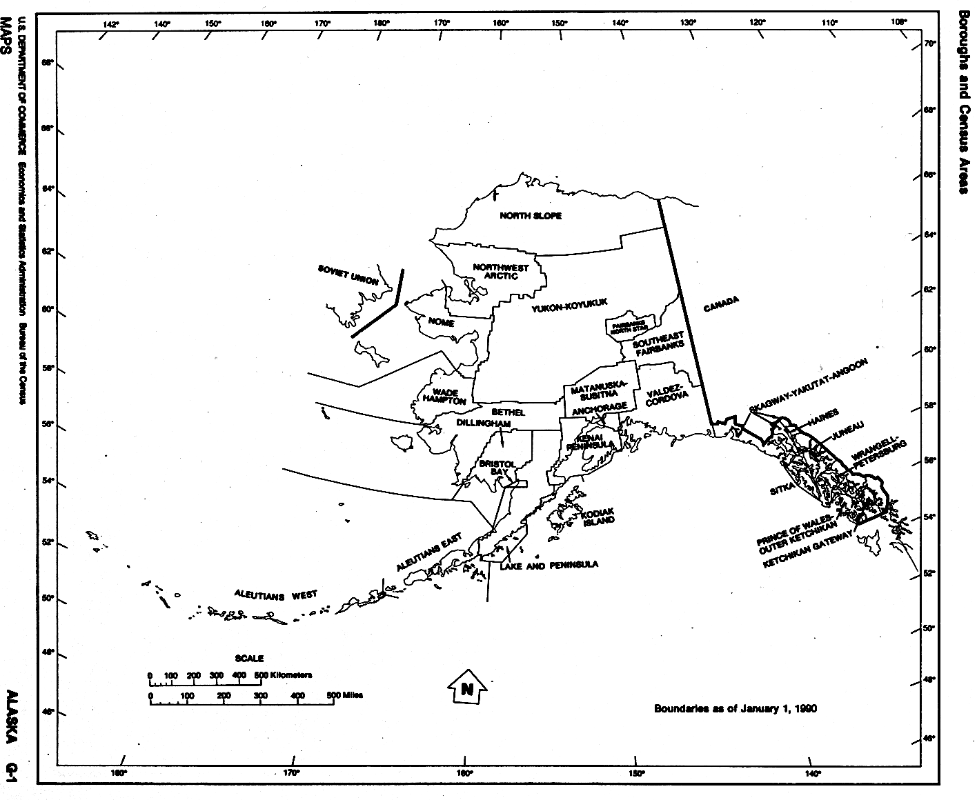
Images of aurora borealis (northern lights) by photographer Jan Curtis. http://climate.gi.alaska.edu/Curtis/curtis.html  » Boroughs of Alaska
Census Bureau map showing outlines and names of the state's boroughs and census areas. http://www.lib.utexas.edu/maps/states/alaska.gif » Color Landform Atlas: Alaska
Includes a series of 10 shaded relief maps, covering both the entire state and enlargements of individual areas. http://fermi.jhuapl.edu/states/ak_0.html » Current Seismicity for Alaska
Map from the National Earthquake Information Center shows recent earthquake activity. Clicking on an earthquake site brings up details. http://neic.usgs.gov/neis/current/alaska.html » Earthquakes in Alaska
Map showing overall geologic setting that produces earthquakes, along with fault lines and references to past and possible future earthquakes. http://ncweb-north.wr.usgs.gov/prepare/alaska/ » Geophysical Institute Map Office
USGS topographic and geologic maps of Alaska. http://www.gi.alaska.edu/services/MapOffice » Perry-Castañeda Library Map Collection
Alaskan maps provided by the University of Texas at Austin http://www.lib.utexas.edu/maps/alaska.html » Pictorial Tourism Maps
Maps cover southcentral and urban areas, surrounded by border of advertising. http://www.freealaskamap.com/ » Potentially Active Volcanoes
Map with information about almost 40 of the state's potentially active volcanoes. Information for each volcano includes name, type, photograph, elevation, and links to USGS information. http://www.nationalatlas.gov/dynamic/dyn_vol-ak.html  » Route of the Harriman Alaska Expedition 1899
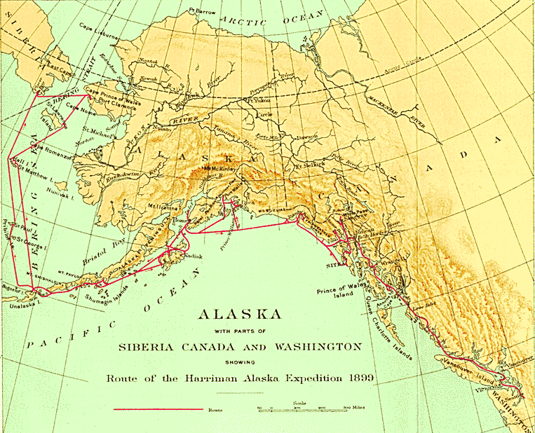
Topographic map with route shown, along the Alaska coast up to the Bering Strait and return. http://rmc.library.cornell.edu/Alaska/images/Alaska-Map.Gif » State Regional Maps
Maps showing the five regions of the state, with major rail and ferry connections. http://www.alaskatravel.com/resources/alaska-maps.html This category needs an editor
Last Updated: 2007-11-29 06:10:01
The content of this directory is based on the Open Directory and has been modified by GoSearchFor.com
|
